What are high and low pressure? How do they occur and what is their relationship to the weather?
We often hear the terms "high pressure" and "low pressure" in weather forecasts. What exactly are these "high pressure" and "low pressure" systems that change the weather as they approach the area where we live? And why does it tend to be sunny when high pressure arrives and rainy when low pressure arrives?
Air pressure is the force of air pushing on the ground and our bodies.
Before we talk about high and low pressure, let's explain what air pressure is.
Air pressure is the force of air pushing. The earth has air, and the air above the ground pushes the ground. And although we are not usually aware of it, our bodies are also pushed by the air. We just don't feel the force of the air as much because our bodies are pushing back with the same amount of force that the air is pushing on us.
Atmospheric pressure decreases with elevation. This is because the higher you are, the less air is piled up above that location. If you take a bag of candy bought at the foot of a mountain to the top of the mountain, the bag expands. This is because the air pressure at the top of the mountain is lower, while the amount of air inside the bag remains the same, so the air pressure inside the bag is greater than outside, and the air inside the bag pushes the bag toward the outside.
The unit of atmospheric pressure is hPa (hectopascal). You have probably heard about it in news reports of typhoons. The average atmospheric pressure at 0 m above sea level (the average height of the sea surface in the nearby ocean) is about 1013 hPa, and this value is also called 1 atmospheric pressure.
What are the criteria for high and low pressure?
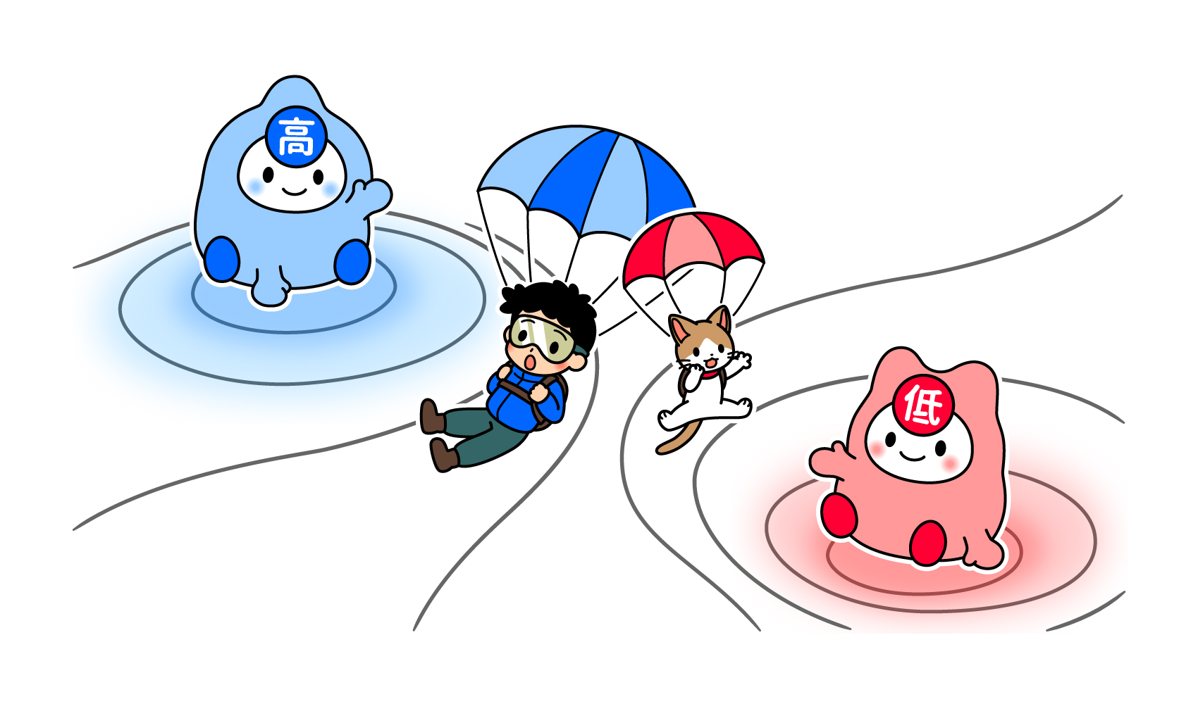
Now let's return to the topic of high and low pressure. High pressure, as the name implies, means high atmospheric pressure. And low pressure means low pressure. Then, what is the criterion to judge as high pressure or low pressure, higher or lower than 1 atm = 1013 hPa?
The answer is that "a place with higher atmospheric pressure than its surroundings" is a high pressure area. And likewise, "a place with lower atmospheric pressure than its surroundings" is a low pressure area. There is no numerical standard for either.
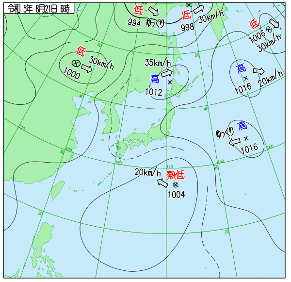
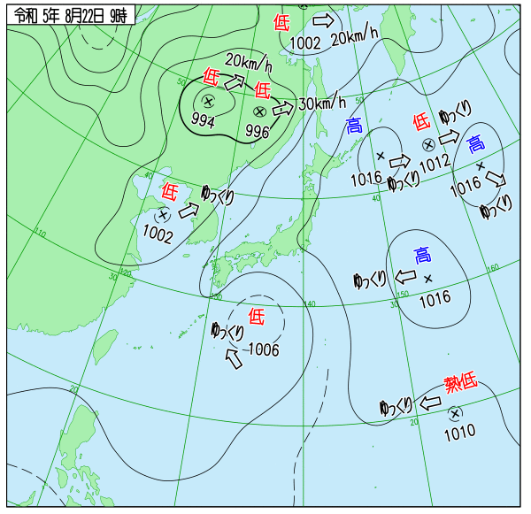
Take a look at the weather chart below. The "low" refers to an extratropical cyclone, "thermocyclone" refers to a tropical cyclone (typhoon egg), and "high" refers to an anticyclone, and the numbers are pressure values. The high pressure in the middle of Figure 1 is 1012hPa, and the low pressure off the Pacific coast of Hokkaido in the weather map in Figure 2 is also 1012hPa. 1012hPa in the weather map in Figure 2 is a low pressure because it is surrounded by three high pressure systems and is like a valley, "where the pressure is lower than the surrounding area. Thus, the same 1012hPa can become a high pressure area or a low pressure area depending on the surrounding atmospheric pressure.
How it rains when a low pressure system approaches
So what is happening at locations with high and low pressure, respectively?
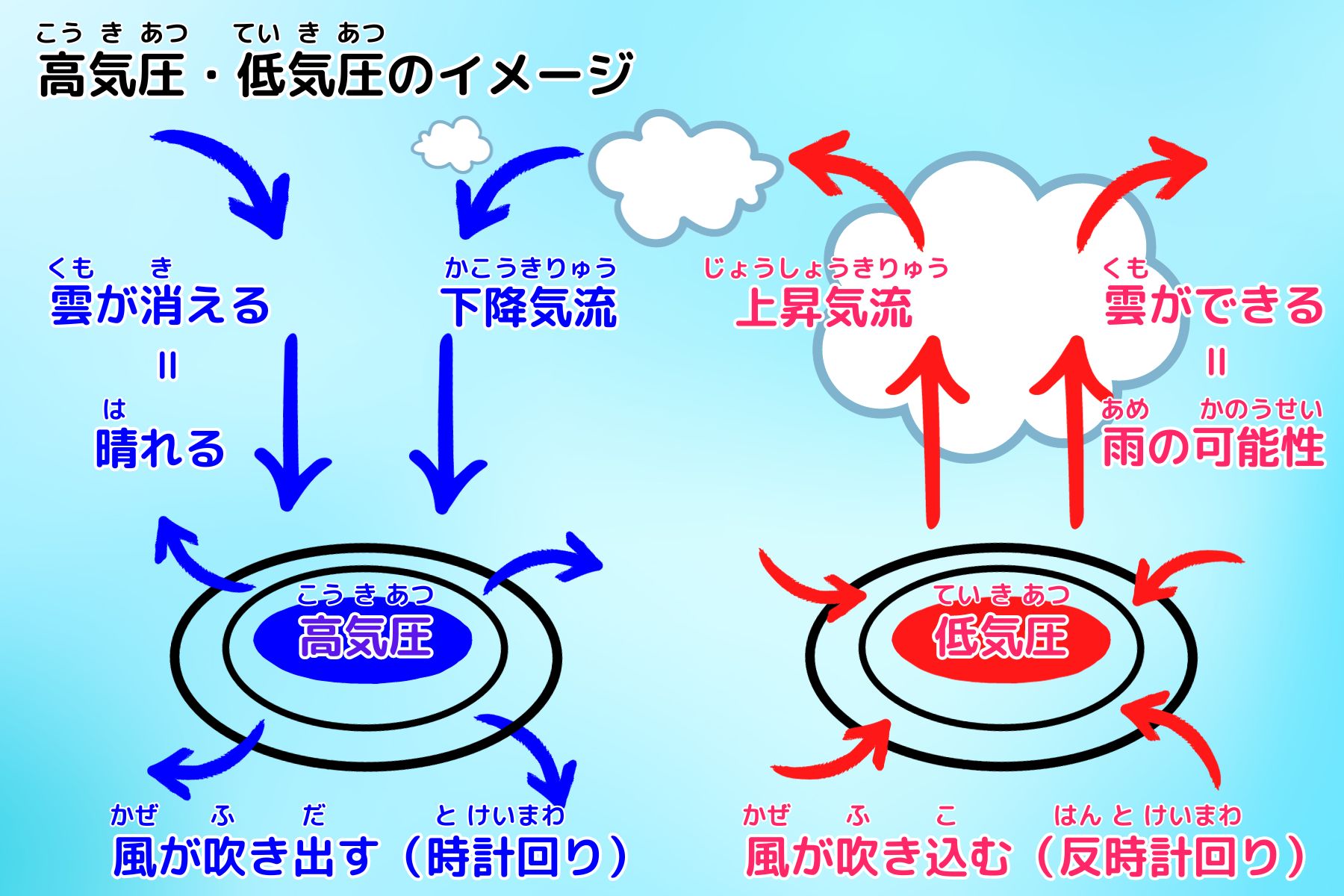
First of all, in low-pressure areas, there is an updraft. As the air rises, the temperature drops. Then the water vapor in the air turns into water, which forms clouds, and from the clouds comes rain. Places with low pressure tend to have rainfall because of the rising air currents.
And where there is high pressure, there is a downdraft. When the air descends, the clouds disappear, which is why it is easier to clear the sky in places with high pressure.
One of the causes of the formation of high and low pressure systems is the difference in the ease of temperature change between land and sea.
For example, when the sun's rays hit the land in the same way, the land heats up quickly, while the ocean does not warm up as quickly. The temperature then rises faster on land. As the temperature rises, the air becomes lighter and rises, creating a low pressure system on land. And since the ocean is colder than land, the air is squeezed and air flows into the sky from the surrounding area. The weight of the air from the ground to the sky is heavier than the surrounding air, so an anticyclone is created.
In high pressure areas, a downdraft occurs, but the air that has descended to the ground cannot go underground, so it blows outward laterally. The air then flows toward the low-pressure area. Thus, air moving from high pressure to low pressure is "wind".
Furthermore, let's look at the relationship between atmospheric pressure and wind during the fall and winter. In the Northern Hemisphere, daylight gradually becomes shorter, the sun's altitude lowers, and it gets colder. At this time, the land cools faster than the sea because the land temperature changes more easily than the sea. This in turn causes a high pressure system to form on land and a low pressure system to form in the ocean. In the vicinity of Japan, high pressure forms over Siberia in the west and low pressure forms over the sea in the east. This is called the winter pressure pattern of high in the west and low in the east. And from the high pressure in Siberia, cold wind blows toward the low pressure at sea. This is the winter monsoon.
Text/Akiko Imai