What is the length of one revolution of the earth?
Answer: About 40,000 km.
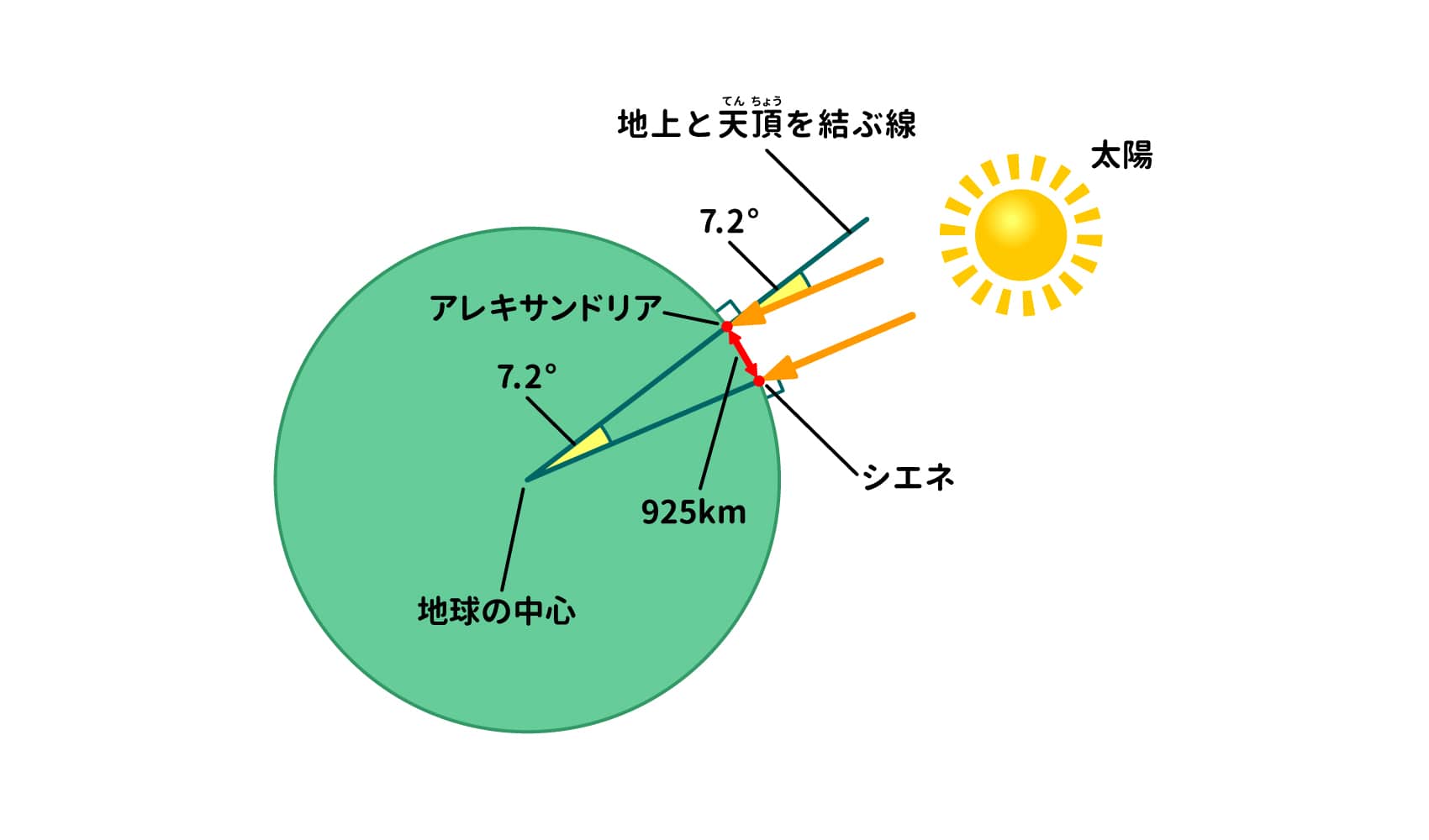
The first person in the world to calculate the distance around the earth (total circumference) was an ancient Greek named Eratosthenes (275 B.C.-194 B.C. 1). Eratosthenes, an Egyptian scholar of mathematics and astronomy and director of the Library of Alexandria, learned that there was a deep well in Syene (present-day Aswan), and that sunlight could reach its surface only at noon on summer solstice days. However, in Alexandria, north of Syene, the surface of the well does not receive light even on the summer solstice. What is the difference?
This is because the earth is a sphere. At noon on the summer solstice in Syene, the sun's rays shine at the zenith (directly above), so there are no shadows and the light reaches the surface of the water. If the earth were flat, the same light would shine on Alexandria. However, if the earth were spherical, the sun's rays would not reach the surface of the water because the sun's rays do not shine from the zenith. Eratosthenes used this difference to calculate the circumference of the earth.
Eratosthenes first measured the height (angle) of the sun at noon on the summer solstice in Alexandria. As a result, he found that the sun was visible 7.2° south of the zenith. Next, the distance between Syene and Alexandria was determined to be 925 km between the two cities. Alexandria was then assumed to be directly north of Syene. Given these three conditions, we can derive the circumference of the earth, or more precisely, the length of the meridian line connecting the North and South Poles.
Since 925 km is 7.2/360ths, or 1/50th, of the total circumference, the total circumference is 925 x 50 = 46,000 (km). We now know that the meridian is about 40,000 km long, but Erasthenes' calculation was only about 15% larger than that.
Ino Tadataka (1745-1818), a former merchant, astronomer, geographer, and surveyor of the Edo period, was the first person in Japan to measure the size of the earth. Ino, who is famous for creating the "Great Map of the Maritime Zone of Japan," was the first person to measure the latitude and longitude of the earth.*It is said that he went out to survey the earth to determine its entire circumference from 1°! 2) The following is a list of the most common problems with the
Ino made surveying and astronomical observations while traveling straight north along the Oshu-kaido Road during the first survey, and determined the length of 1° latitude (arc length) to be 106 km. Based on this arc length, the length of the meridian is approximately 38,000 km. In the second and third surveys, the arc length was determined to be "28 ri 2 min" (110.7 km), from which the length of the meridian was calculated to be about 39,900 km. Ino's figure of "28 ri 2 min," the arc length he derived from his survey, had an error of 0. 2%3 when converted to today's metric system.) This is astonishingly accurate. Incidentally, the distance Ino walked during his 15-year surveying trip was approximately 40,000 km, which is almost the same as the circumference of the earth.
Chikyu is written in Chinese characters as "earth sphere," but in reality it is shaped like a slightly squashed sphere, like a tangerine. Therefore, the length of the equator, which divides the earth into north and south, and the meridian are different. The length of the equator is about 40,75 km, and the length of the meridian is about 49,000 km.
Latitude: The latitude is the distance from the equator to 90° from north to south. The northern side of the equator is called north latitude and the southern side is called south latitude4). The northernmost point in Japan is 45°33′26′N on Etorofuri Island in Hokkaido, and the southernmost point is 20°25′31′N on Okinotori Island in Tokyo5).
reference data
(1) Geodetic Society of Japan / supervisor, Shuhei Okubo / editor. Is it true that the earth is round? 50 Questions for Geodesists. Asahi Shimbun, 2004 * Part of the book is available on the website of Nippo Corporation: https: //www.nippo1.co.jp/earth/index.html
(2) Geospatial Information Authority of Japan, Ministry of Land, Infrastructure, Transport and Tourism, "Surveying the Past": https://www.gsi.go.jp/common/000143706.pdf
(3) Japan Reclamation Dredging Association, "Kaihatsu-sha-tachi: Nihon maritime great men row Biographies of the first man to know the shape of Japan, Ino Tadataka." Marine Voice 21".November 2017, vol. 258, https://www.umeshunkyo.or.jp/108/kaitakusya/258/index.html
(4) Ministry of Land, Infrastructure, Transport and Tourism, GSI pamphlet, "What are longitude and latitude?":https://www.gsi.go.jp/KIDS/PAMPHLET/p9.htm
(5) Geographical Survey Institute, Ministry of Land, Infrastructure, Transport and Tourism, "Light Latitude of Japan's East-West and North-South End Points": https://www.gsi.go.jp/KOKUJYOHO/center.htm
Supervisor: Mitsuharu Oyama

Born in Tokyo in 1957. Completed a master's degree at Tokyo Institute of Technology. After working as a physics teacher at a high school, a chief instructor at Chiba Prefectural Board of Education, and principal of Chiba Prefectural Chousei High School, he is currently a professor at Shumei University School Teachers' College, where he teaches lectures and exercises on teaching methods for "Science and Mathematics Exploration" and "Integrated Learning Time". He has appeared in many science experiment classes and TV experiment programs. He is also a project advisor for the Chiba City Science Museum, an executive director of the Japanese Society of Physics Education, a member of the Japanese Society for Science Education and the Japanese Society for Science Education, and a member of the editorial board of the monthly magazine "Science Education.