Where and how are typhoons formed?
Answer: Water vapor rises from the tropical oceans to form clouds, which develop greatly.
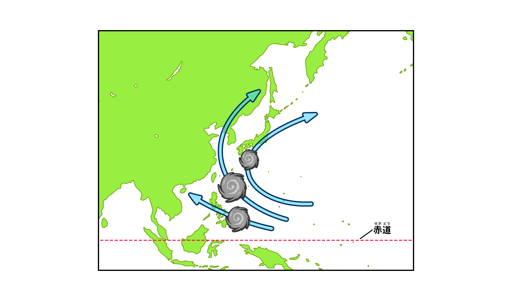
A typhoon is a "tropical cyclone" that develops over tropical seas, either in the Northwestern Pacific (the area north of the equator and west of 180°E) or in the South China Sea. Among them, a typhoon is one with a 10-minute average maximum wind speed of 17.2 m/s or higher1).
Why do typhoons form in tropical oceans? The reason is that the sun shines throughout the year and its heat causes seawater to evaporate, creating lots of water vapor. Water vapor is the energy source for typhoons.
The energy of a typhoon is water vapor. In other words, the tropical ocean is a place where typhoons can continuously receive energy. Let's follow the formation of a typhoon a little more closely*1.
Water vapor created by heating seawater is lighter (less dense) than the surrounding air, so it rises into the sky. This air flow is called updraft This is called "water vapor. Water vapor that rises high in the updrafts is cooled by the cold air above and becomes water vapor, which forms clouds (see related article "What are clouds made from and how are they formed? The air around it flows in and grows into a cumulonimbus cloud.) Then, moist air flows in from the surroundings and grows into a cumulonimbus cloud (see related article "How do cumulus clouds form? (See "The World's Most Popular Cities").
In the process of growing, clouds release a lot of heat into the atmosphere. This heat heats the surrounding air, causing the air to expand and become lighter (less dense), which lowers the atmospheric pressure and creates a low-pressure system. Since air has the property of flowing from a place with high pressure to a place with low pressure, moist air flows in from the surroundings in a leftward (counterclockwise) spiral toward the center of the low-pressure system*2, which strengthens the upward momentum and develops cumulonimbus clouds. As the pressure at the center decreases, the rotation of the vortex speeds up, and eventually a typhoon is formed.
If you look at a typhoon from above on a satellite photo, you can see that there is a cloudless area in the center of the typhoon's vortex. This is called the "eye" of the typhoon. In the eye of a typhoon, winds are weak and blue sky can be seen from the ground. On the other hand, the "eyewall" surrounding the eye is made up of tall cumulonimbus clouds, under which storms occur. The diameter of the eye of a typhoon is about 20 to 200 km. The smaller and clearer the eye of a typhoon is, the stronger the force of the typhoon is.
Like typhoons, tropical cyclones develop into "cyclones," "hurricanes," and "typhoons. The major difference is the location of occurrence and the intensity.
First, a cyclone is a tropical cyclone that occurs in the northern Indian Ocean, such as the Bay of Bengal or the Arabian Sea, with maximum wind speeds of 17 m/s or more. The term is sometimes used broadly to refer to cyclones. Hurricanes are tropical cyclones that originate in the North Atlantic Ocean, the Caribbean Sea, the Gulf of Mexico, and the northeast Pacific Ocean east of 180°W, and have a one-minute average maximum wind speed of 33 m/s or more.
Typhoons have a similar name to typhoons, but international agreements define "typhoons" as those with maximum wind speeds of 33 m/s or higher3). Typhoons, on the other hand, are determined by Japan's own standards. By international standards, typhoons are called "tropical storms.
1 The process of typhoon formation can be seen in the "Rotation of Nature" section of the JPO's "Junior Innovation Fest - Mawaru Exhibition" kids' page.
2 In the northern hemisphere, the Earth's rotation creates a leftward (counterclockwise) vortex.
Article published: March 2022
reference data
(1) Japan Meteorological Agency, "About Typhoons": https: //www.jma.go.jp/jma/kishou/know/typhoon/1-1.html
(2) Japan Weather Association, "tenki.jp," "How Typhoons Work": https: //tenki.jp/bousai/knowledge/5accc20.html
(3) Japan Weather Association, "tenki.jp," "What is a typhoon?": https: //tenki.jp/docs/note/typhoon/page-1.html
Supervisor: Mitsuharu Oyama
Born in Tokyo in 1957. Completed a master's degree at Tokyo Institute of Technology. After working as a physics teacher at a high school, a chief instructor at Chiba Prefectural Board of Education, and principal of Chiba Prefectural Chousei High School, he is currently a professor at Shumei University School Teachers' College, where he teaches lectures and exercises on teaching methods for "Science and Mathematics Exploration" and "Integrated Learning Time". He has appeared in many science experiment classes and TV experiment programs. He is also a project advisor for the Chiba City Science Museum, an executive director of the Japanese Society of Physics Education, a member of the Japanese Society for Science Education and the Japanese Society for Science Education, and a member of the editorial board of the monthly magazine "Science Education.