How does hail fall?
Solution: Ice crumbles grow large and fall in clouds.
In the Kanto area, thunderstorms may begin in the early afternoon. In the mountains, watch out for thunderstorms and hail. As summer approaches, we hear more and more about the damage caused by falling hail, such as holes in crops in the fields or dented cars. Where does hail come from and how does it fall?
Hail is a mass of ice 5 mm or larger in diameter that falls to the ground from cumulonimbus clouds1). Cumulonimbus clouds are tall clouds that cause heavy rainfall over a small area and are also called thunderclouds (see related article, "How do cumulonimbus clouds form?) (Related article: "How do cumulonimbus clouds form? The reason why we often hear weather reports of hail and lightning together is that both fall from cumulonimbus clouds.
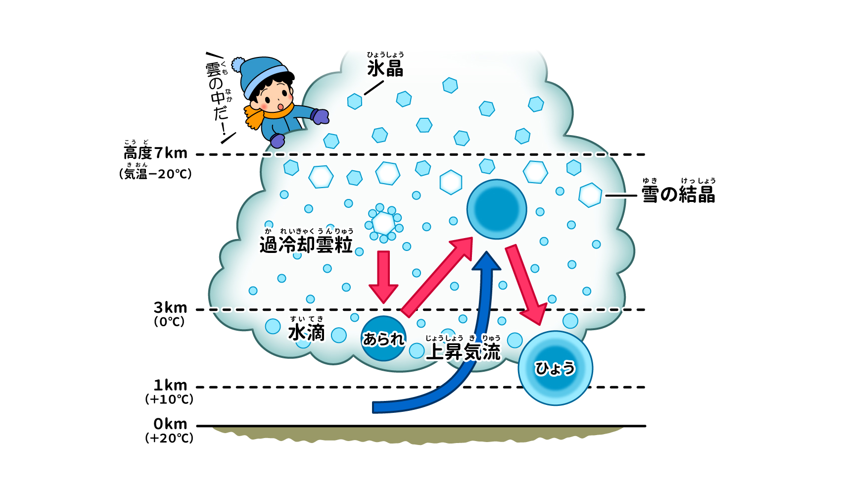
Let's take a look at how hail is formed in cumulonimbus clouds2). Cumulonimbus clouds are made up of small droplets of water and ice crystals, which are formed from water vapor and float in the sky due to "updrafts," the atmospheric flow of moisture evaporated from the ocean and ground moving upward (see related article "What are clouds made of and how are they formed?) Clouds are formed from the ground to more than 10 kilometers above the ground. Clouds can develop from near the ground to 10 km or more in the sky, and even within the same cloud, the temperature varies greatly depending on the height of the cloud. For example, when the temperature is +20°C at an altitude of 0 m, it is +10°C at an altitude of 1 km, 0°C at an altitude of 3 km, -20°C or lower at an altitude of 7 km, and drops to -40°C or lower at an altitude above 10 km. Thus, as the altitude increases and the temperature decreases, the form of water vapor also changes from "liquid (cloud particles only)," "liquid and solid (cloud particles and ice crystals)," and "solid (ice crystals) only. However, within clouds, there are also "supercooled cloud particles," cloud particles that remain liquid even in temperatures lower than 0°C.
When surrounding water vapor attaches to ice crystals, snowflakes are formed (see related article, "Why Does Snow Fall?"). ). When supercooled cloud particles stick to them, the snow crystals become heavier and fall to lower cloud levels. This is "hail. When the hail falls to an area warmer than 0°C (around 3 km altitude), the surface melts and a film of water forms. When they are carried by updrafts back to higher altitudes, the surface of the hail melts.
As the crystals continue to move back and forth in this manner, they grow larger. When the crystals reach a certain size, they can no longer be carried upward by the updrafts because they fall too fast, and they begin to fall toward the bottom of the clouds. If the crystals melt by the time they reach the ground, they form rain, but if they do not melt and reach the ground with a diameter of 5 mm, they are called hail.
When falling hail is sliced into rings, stripe patterns resembling annual rings of trees can be observed on the cross section3). This stripe pattern is evidence that crystals have repeatedly moved up and down in cumulonimbus clouds. The layer formed by supercooled cloud particles is opaque because there are gaps between the particles, but the layer formed by the surface melting into a water film is transparent because there are no gaps. Hail is written in Chinese characters as "hail. It seems to represent the formation of snow crystals wrapped in layers of water.
Article published: July 2022
reference data
(1) Japan Meteorological Agency, "Terms Used in Weather Forecasts, etc. Precipitation": https://www.jma.go.jp/jma/kishou/know/yougo_hp/kousui.html
(2) Kentaro Araki, The World's Most Wonderful Cloud Classroom.2018. Sansai Books.
(3) Kentaro Araki, "Understanding all the mysteries of the sky! The amazing illustrated book of the weather".2021.KADOKAWA
(4) Kumagaya District Weather Station, Japan Meteorological Agency, "Hail the Size of Pumpkins": https: //www.jma-net.go.jp/kumagaya/shosai/chishiki/hyou.html
(5) Weathernews, "Hail and Hail: The Difference and Dangers": https://weathernews.jp/s/topics/202004/160165/
Supervisor: Mitsuharu Oyama
Born in Tokyo in 1957. Completed a master's degree at Tokyo Institute of Technology. After working as a physics teacher at a high school, a chief instructor at Chiba Prefectural Board of Education, and principal of Chiba Prefectural Chousei High School, he is currently a professor at Shumei University School Teachers' College, where he teaches lectures and exercises on teaching methods for "Science and Mathematics Exploration" and "Integrated Learning Time". He has appeared in many science experiment classes and TV experiment programs. He is also a project advisor for the Chiba City Science Museum, an executive director of the Japanese Society of Physics Education, a member of the Japanese Society for Science Education and the Japanese Society for Science Education, and a member of the editorial board of the monthly magazine "Science Education.