How "sunny" and how "cloudy" is it? Weather Words Explained
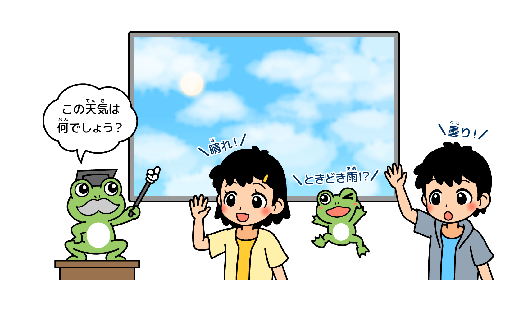
Many people probably open the curtains when they wake up in the morning to check the sky and say, "It's a beautiful day," or "It's cloudy. On the news, the weather forecast is often expressed in a slightly more dubious manner, such as "sunny and cloudy" or "cloudy with a chance of rain. You may also hear phrases such as "a probability of precipitation of X%" for rain, or "hotter than normal" for temperatures. But, for example, how much is "sunny" and how much is "cloudy"? When does "temporary rain" mean rain, and for how long? Can you answer these questions? Here, we will explain the correct meanings of words often used in weather forecasts, which are somewhat obvious but actually tend to be a bit ambiguous.
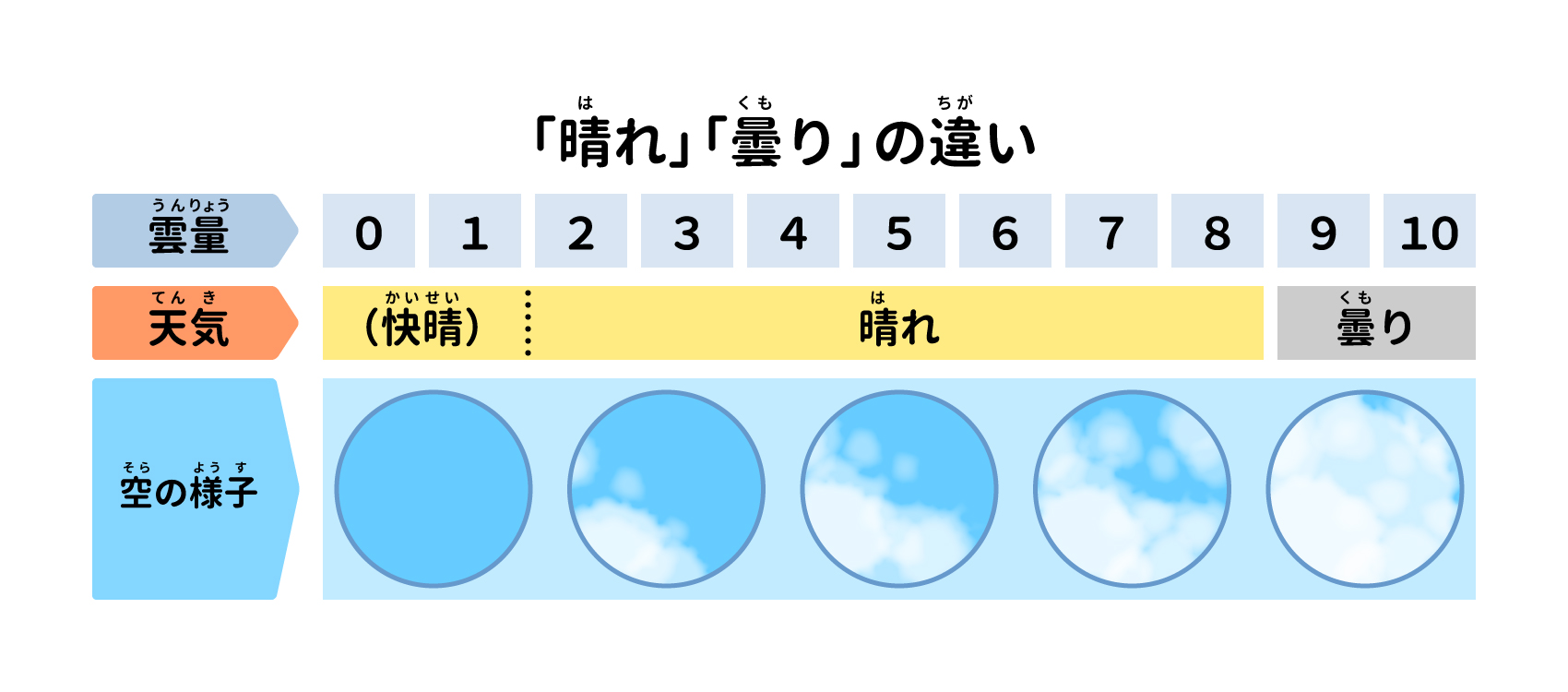
Half of the sky is cloud. Is this clear? Cloudy?
We know in our heads that it is sunny when blue sky peeks out and cloudy when there are many clouds, but is it sunny or cloudy when most of the sky is covered with clouds and a glimpse of blue sky peeks out? When half of the sky is covered with clouds, which is it?
The Japan Meteorological Agency distinguishes weather based on the ratio of cloud cover to the entire sky. When the percentage of the sky covered by clouds (cloud cover) is between 0 and 80%, the weather is "sunny," and when it is between 90 and 10%, the weather is "cloudy. It may seem strange that 80% of the sky is "clear" even when clouds cover 80% of the sky, but cloudy weather really only occurs when the sky is full of clouds.
Until now, the Japan Meteorological Agency has used "visual observation," in which staff members determine whether the weather is clear or cloudy by looking at it with their eyes. However, with the development of observation technology, visual observation by employees is being replaced by machine observation. Today, visual observations are conducted only at two locations in Japan, Tokyo and Osaka. Until then, when cloud cover was 0 to 10%, the forecast was announced as "clear skies," but since clear skies are difficult to discern without visual observation, they are now included in "clear skies. Similarly, when cloud cover is 9 or more, roll cloud, roll stratus cloud, and roll cumulus cloud (see related article "How many types of clouds are there? If there is a large number of " " (" "), it was announced as "Light Cloudy," but since it is also difficult to discern without visual inspection, it is now included in the "Cloudy" category.
Does a drizzle or a drizzle count?
In weather reports, terms such as "50 mm of very heavy rain" are used. For example, this 50mm means that rainfall will accumulate to a depth of 50mm below the ground. When it rains more than 1mm, a rain symbol appears in the weather forecast.
However, rain may occur even when the rain symbol is not displayed. Rain of less than 1mm is, for example, a light drizzle or a drizzle of rain. When the weather is cloudy, but it is raining, you can expect less than 1mm of rain. it may be raining less than 1mm. When you are outside for a long time, even this kind of rain will make you wet. If the sky is cloudy and heavy, it is a good idea to wear a raincoat or carry a folding umbrella just in case. Some weather forecasting apps indicate when less than 1 mm of rain will fall with a closed umbrella symbol. The following table summarizes the intensity and direction of rainfall on the Japan Meteorological Agency's website.
Source: Produced by the editorial department based on the Japan Meteorological Agency HP (https://www.jma.go.jp/jma/kishou/know/yougo_hp/amehyo.html)
The probability of precipitation has nothing to do with the intensity or extent of rainfall.
The probability of precipitation is the probability of rain or snowfall. For example, a "40% chance of precipitation" means that rain has fallen four times in the past when similar pressure patterns and other weather conditions have appeared ten times. The probability of precipitation does not mean that 80% of the time it will rain more heavily than 10% of the time, or that it will rain over a wider area. It is a number that indicates the likelihood of rainfall and does not indicate the amount or extent of rainfall.
For example, a forecast that says, "There is a 40% chance of rain in the Tokyo area between noon and 6 p.m." means that there is a 40% chance of rain or snow of 1 mm or more at any location in the Tokyo area between noon and 6 p.m.
What is the difference between "later," "temporarily," and "sometimes"?
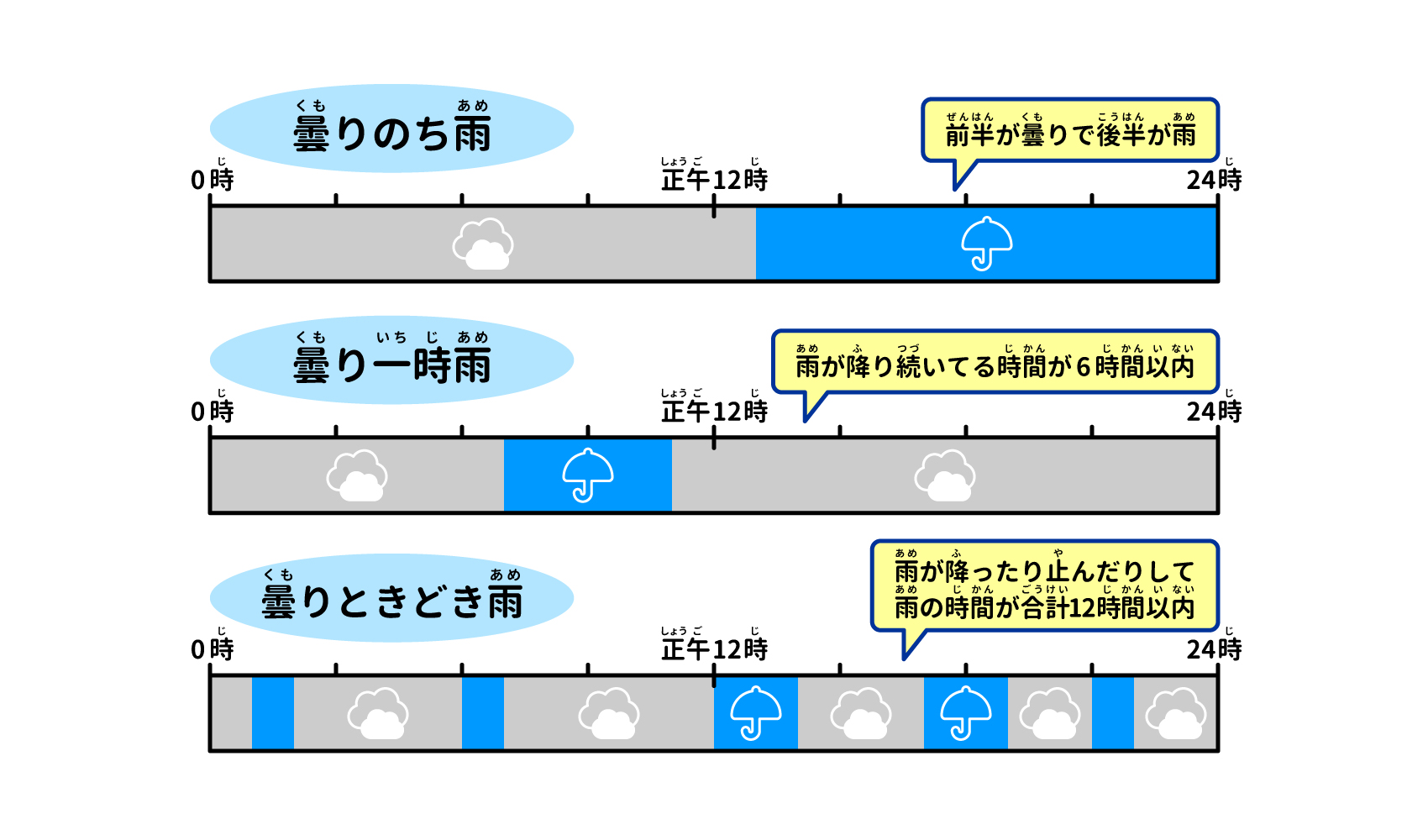
In weather forecasting, the words "chi," "toki togi," and "temporarily" feel the same, but have slightly different meanings.
The "chi" in "cloudy and clear" is used when the first half of the forecast period (e.g., from midnight to midnight of the next day) is cloudy and the second half is clear.
Cloudy with occasional rain" and "Cloudy with occasional rain" are both used when rain falls on and off. However, the total time of rainfall differs.
In the case of "cloudy spells of rain," the duration of continuous rain is shorter than 1/4 (6 hours) of a 24-hour period.
In the case of "cloudy and sometimes rainy," the rain is intermittent, with periods of rain interspersed with periods of rain when it has stopped raining (about an hour or more), and the total duration of rainfall is shorter than 1/2 (12 hours) of a 24-hour period.
The same conditions apply to "sometimes sunny" and "temporarily cloudy," which are determined by whether the weather is sunny or cloudy and how long the weather condition lasts.
Now, you also often hear the term "rain in places". This means that rain will fall within a smaller area than half of the forecasted area. For example, in the case of the Tokyo area, "tokoro ni yori" is used when rain falls within a small area, such as in Hachioji City, where only evening showers are expected.
Wind speeds are 10-minute averages.
Natural wind does not always blow at the same strength as the wind from a fan. Therefore, when measuring wind speed, the Japan Meteorological Agency releases a 10-minute average. The instantaneous wind speed is the average of three seconds. Instantaneous wind speed can be 1.5 to 3 times higher than wind speed. The following table summarizes wind strength and blowing direction on the JMA website.
Source: Produced by the editorial department based on the Japan Meteorological Agency HP (https://www.jma.go.jp/jma/kishou/know/yougo_hp/kazehyo.html)
The point between "normal" and "extreme weather" is "30 years."
You often hear phrases such as "above normal temperatures" in weather reports. The "normal" is calculated from the average of the last 30 years of observations, and is used for a variety of other things in addition to temperature, such as precipitation and snow depth. Normal values are updated every 10 years, and the current normal is the average of 30 years of observations from 1991 to 2020. The most recent update was in 2021, but the average temperature tends to be higher than the normal before the update, probably due to the effects of recent global warming. The next update will be in 2031, and it will be interesting to see how the anomalies will change.
Extreme weather generally refers to weather phenomena that deviate significantly from those experienced in the past. In principle, the Japan Meteorological Agency defines an extreme weather event as "a phenomenon that occurs once every 30 years or less in a certain place (region) and at a certain time (week, month, season). There are various causes of extreme weather events, such as westerly wind meandering and the El Niño phenomenon, but most of them are caused by the Earth's long-standing and repeated activities. In recent years, however, global warming is also considered to be one of the causes of extreme weather events.
Text/Akiko Imai